Cabo de Gata's Volcanoes, Flamingos and Sea: Geology, Salt Flats, Snorkelling and When to Go
Most visitors come to Cabo de Gata for its beaches, but the beaches are only the edge of something larger. Behind them lies a volcanic landscape millions of years old, one of the driest corners of Europe, salt flats where flamingos feed all year, a lighthouse above a reef of volcanic chimneys, and, below the water, a protected sea that is among the best places in Spain to snorkel.
This guide explores that wider park: the geology that shaped it, the salt flats and their birds, the lighthouse and the Mermaid Reef, the marine reserve and how to snorkel it, the old gold mines, the best walks, the climate and the best time to visit.
A protected landscape
Few places in Spain carry as many layers of protection.
- Declared a natural park by Decree 314/1987 of 23 December, it was Andalusia’s first maritime-terrestrial natural park.
- The Cabo de Gata-Níjar Marine Reserve was established in 1995.
- UNESCO declared it a Biosphere Reserve on 5 November 1997.
- It has belonged to the European and Global Geoparks Network since 2006.
- The Cabo de Gata salt flats were listed as a Ramsar wetland in 1990.
The geopark alone covers 352 km² of land and 120.12 km² of protected sea, 49,152 ha in all, and people have lived here for a very long time: the area has been inhabited since the Neolithic.
Volcanoes by the sea
The volcanic story
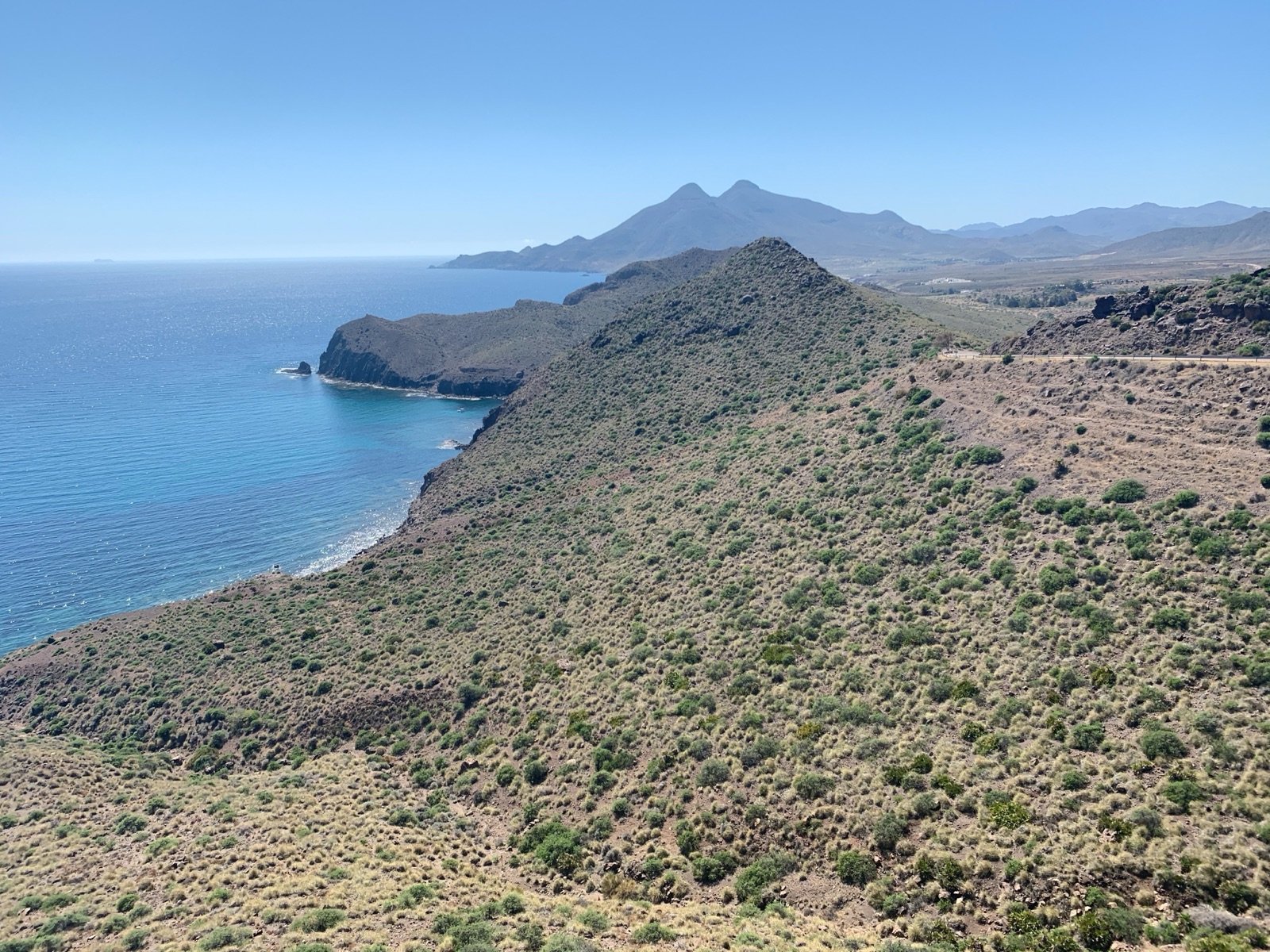
Cabo de Gata is a volcanic landscape, and once you know it, you see it everywhere. Volcanic activity began about 16 million years ago and ended about 8 million years ago. Lava flows, domes and volcanic chimneys make up the hills and headlands, and wind and sea have carved them into the coves and strange rocks that give the coast its character.
Most of the volcano is hidden. Only 5 percent of the volcanic complex rises above the water; the other 95 percent lies below the sea. The cliffs and headlands you see are the tops of a much larger structure.
Los Frailes
The highest point is a volcano. Los Frailes, the tallest volcano, has two domes, the higher nearly 500 metres above sea level, and a trail to the summit. From the top, the view runs down the coast over the villages and the sea.
Mesa Roldán’s fossil reef
Some of the volcanic domes have oddly flat tops, and the reason is remarkable. Mesa Roldán’s flat top is a fossil coral reef that grew on the dome about 6 million years ago, when it was under water. As sea levels fell, the reef was left high and dry, a record of a time when this volcano stood beneath the sea.
The cliffs
The volcanic Sierra del Cabo de Gata falls to the sea in jagged 100-metre cliffs, cut by gullies into small coves and beaches. Its 63 km of cliffs form the best-preserved coastline of the Spanish Mediterranean. Seen from a boat or a kayak, at sea level, the layers of volcanic rock and the sea caves at their foot are at their most striking.
The desert by the sea
The driest corner of Europe
Cabo de Gata is astonishingly dry. It is the only region in Europe with a hot desert climate (Köppen BWh). Almería province is the driest area of Europe, with about 20 cm of rain a year, and the cape itself is drier still: Cabo de Gata is the driest place in the Iberian Peninsula, with 150 to 170 mm of rain a year and a record low of 52 mm in 1981. Inland, the Tabernas Desert, called mainland Europe’s only desert, is about 30 km away.
Life in a dry land
Dry does not mean empty. There is enough moisture for nearly 1,000 plant species, including the European fan palm. At Genoveses, small dunes with prickly pears and agaves back the beach, and the whole flora is adapted to long months without rain.
The salt flats and their flamingos
Working salt pans
On the south-western side of the park, between the village of Cabo de Gata and the lighthouse, lie the salt flats. The Cabo de Gata salt flats are the only ones still worked industrially in eastern Andalusia, producing about 40,000 tonnes of salt a year. The salt flats are separated from the sea by a 400 m sand bar and are a Ramsar site.
The birds
The salt pans are one of the richest bird habitats on the coast. More than 100 bird species have been recorded at the salt flats, about 70% of them migrants resting on passage. The stars are the flamingos:
- Flamingos are present at the salt flats all year round.
- In late July and early August the flamingo colony can number thousands; a few hundred stay all year.
Watching them
There are two bird-watching hides; bring binoculars, because they are set well back from the birds. Early morning and late afternoon, with low sun and cooler air, are the best times, and the flamingos’ pink stands out against the white salt.
The lighthouse and the Mermaid Reef
The lighthouse
At the southern tip of the park, the road ends at the lighthouse. The Cabo de Gata lighthouse was built in 1863 to warn passing ships off the coast. Beside it, a viewpoint looks down on one of the most famous views in the park, and there is a tourist information point next to the viewpoint.
The reef
Below the viewpoint, dark rocks rise from the clear water. The reef’s rocks are old volcanic chimneys, dark from the material they erupted, and the Mermaid Reef rocks are thought to be the remains of an old volcanic structure. The legend is older than the geology: the Mermaid Reef is probably named after the monk seals that once lived here, which old sailors could mistake for mermaids; there are none today.
A short path leads down to a tiny cove with room for barely 4 or 5 towels at low tide, and the waters around the reef are a favourite with divers. Sunset from the viewpoint is one of the classic moments of a visit.
Under the water
The marine reserve
Cabo de Gata’s sea is protected as carefully as its land. The marine reserve covers 12,000 hectares, and a 120 km² part of the protected area is a marine reserve reaching down to 60 m. The clear water, rocky bottoms and seagrass meadows make it one of the best places for snorkelling and diving in Spain.
What you will see
- Close to shore. In just a metre of water you can see several fish species; the richest marine life is at 5 to 10 metres.
- Fish. Species include grouper, sea bass, sea bream, scorpionfish, red mullet, cuttlefish, squid and octopus.
- Seagrass. Posidonia meadows can be seen from 15 metres deep, a vital nursery for marine life. At Genoveses, a vast Posidonia meadow lies offshore, and the seagrass often washes up on the shore.
The rules
- Spearfishing is completely prohibited.
- Scuba diving needs an authorisation from the Government Sub-delegation in Almería or the park offices. Ask your dive centre how this is arranged.
- Look without touching or taking anything; the reserve exists to let marine life recover.
Snorkelling from a kayak or boat
The best snorkelling is along the rocky edges of the coves, many of which are reached only from the sea.
Kayak and snorkel tour. Paddle along the volcanic cliffs to coves reached only from the sea, then snorkel with a full-face mask. Snorkel gear included. About 3 hours.
Six-coves boat route from Carboneras. A small boat (11 passengers at most) past coves, volcanic cliffs and sea caves, with a swim and snorkel stop; mask included. About 2 hours.
Sailing to Los Muertos beach. A family-friendly sailboat from Carboneras, with a snorkelling stop in a cove. About 3 hours.
Gold and ghosts: Rodalquilar
The park also has an industrial past. Gold mines worked the hills around Rodalquilar from 1940 to 1966; mining here goes back to the Romans. The remains of the mining era are part of the landscape around the village, an atmospheric contrast to the beaches and a reminder that this dry, remote coast was once a place of hard industrial work.
People and history
The volcanic hills have never been easy to farm, but people have lived here for thousands of years. The area has been inhabited since the Neolithic, and its cultural heritage runs from peoples as ancient as the Tartessians and Phoenicians to the windmills and farmhouses of more recent times.
The sheltered bays have drawn fleets. The beach is named after a fleet of 200 Genoese ships that camped in the bay in 1147 before the attack on Almería by the forces of Alfonso VII, and in 1571 a Spanish fleet of more than 300 ships and 30,000 men gathered in the bay before the Battle of Lepanto. Along the coast, the boat trip from San José passes the ruins of watchtowers and castles that once guarded against raiders from the sea.
Later came the lighthouse, built in 1863, the gold mines of Rodalquilar, and finally protection: the natural park in 1987, which has kept this coast so different from the rest of Spain’s Mediterranean shore. The Los Genoveses trail starts by a windmill restored in 2007, one of many old mills that recall the dry-farmed cereal fields of the past.
Walking in the park
Walking is one of the best ways to understand the landscape, though the heat makes summer walking hard.
- Los Frailes. A trail to the summit of the park’s tallest volcano, for the view down the coast.
- Vela Blanca. Walking on past the barrier at the end of the track, you can climb the Vela Blanca hill for a view over the coves.
- The Genoveses trail. The Los Genoveses trail starts by a windmill restored in 2007 and passes Civil War bunkers on the beach.
- The Morrón de Genoveses. The Morrón de Genoveses hill closes the south of the bay and gives a view over the beach, the Campillo del Genovés and San José.
- To Cala San Pedro. On foot, the path starts from Las Negras; even from the San Pedro car park it is still about 2 km along a narrow path near cliffs.
Carry more water than you think you need, start early, and avoid the middle of the day in summer.
Exploring by 4x4
If you are short of time or do not have a car, a guided 4x4 tour links the landscapes of this guide in one outing.
4x4 tour of the natural park from Almería. A driver and guide take you to a volcano-top view over the beaches, the salt flats and their flamingos, the Mermaid Reef and the fishing village of Cabo de Gata. About 2 hours, departing from Almería.
Boat trip from San José. A guided cruise from San José past untouched coves, old volcanoes and the ruins of watchtowers and castles. About 1h 45m.
The tours page lists them all with live prices.
When to go
The climate
- The annual average temperature is about 19.8 °C.
- Mean daily maximums run from 16.8 °C in January to 28.8 °C in July and 29.6 °C in August; in October the mean maximum is 24.1 °C.
- Ten months of every year are considered arid, and average annual rainfall at the Cabo de Gata lighthouse was around 156 mm (1961–1990), and under 150 mm in recent years.
- Cabo de Gata has on average 119 tropical nights a year.
Season by season
- Spring is ideal for walking and wildflowers, with mild temperatures and free access to the beaches.
- Summer is for the sea: warm water, long days and the best snorkelling, but also heat, crowds and the summer access rules. The population peaks in summer at about 60,000 and is much lower the rest of the year.
- Late July and early August are the peak of the flamingo passage at the salt flats.
- Autumn is many visitors’ favourite: the sea is still warm, the beaches quieter and walking pleasant again.
- Winter is mild and quiet, excellent for walking, birdwatching and the villages.
Travelling responsibly
The park’s fragility is part of its beauty. The same scarcity of water that makes it unique makes it slow to recover from damage, and its popularity puts pressure on the most famous places in summer.
- Use the shuttle from San José in summer instead of driving to Mónsul and Genoveses.
- Stay on paths and tracks; the dunes and their plants are easily damaged.
- Leave the Posidonia where it lies on the beaches; it is natural seagrass, not litter.
- Never feed or disturb wildlife, including the flamingos at the salt flats.
- Take your rubbish home; there are no bins at the wild beaches.
- Respect the marine reserve: spearfishing is prohibited, and diving needs authorisation.
A two-day plan
- Day one, the south-west: the salt flats at dawn for the flamingos, then the lighthouse and the Mermaid Reef viewpoint; an afternoon at Genoveses or Mónsul; sunset back at the lighthouse.
- Day two, the north-east: a morning kayak and snorkel trip or a boat from Carboneras; lunch in a village; the old gold mines at Rodalquilar in the late afternoon, and a walk up Los Frailes or Vela Blanca if the heat allows.
Frequently asked questions
Is Cabo de Gata volcanic?
Yes. Volcanic activity began about 16 million years ago and ended about 8 million years ago. Only 5 percent of the volcanic complex rises above the water.
Where can I see flamingos in Cabo de Gata?
At the salt flats between Cabo de Gata village and the lighthouse, where flamingos are present all year. In late July and early August the colony can number thousands. Two hides overlook the salt pans.
Is Cabo de Gata good for snorkelling?
Very. The marine reserve covers 12,000 hectares; in just a metre of water you can see several fish species, and the richest life is at 5 to 10 metres. Spearfishing is prohibited.
Why is it called the Mermaid Reef?
Probably after the monk seals that once lived there, which old sailors could mistake for mermaids. There are none today.
What is the best time to visit Cabo de Gata?
Spring and autumn, for warm weather, free beach access and fewer crowds. Summer is best for the sea but brings heat and access rules.